2010 South Lamar Blvd
This is the project at the southwest corner of South Lamar Blvd and Hether St, formerly the site of La Feria Restaurant. It was slated to become adminstrative offices (28,332 sf) for JUUL Labs. However, as of August 2021, it is not clear whether the tenants have moved in yet. The original restaurant/retail uses for the ground floor have been eliminated. This webpage contains the following sections:
- Groundwater Discharge Issue
- Site Plan
Groundwater Discharge Issue
Introductory Information
During the excavation and construction of the underground parking garage which started in October 2017 with issuance of the building permit, the geologic formation beneath the building was disrupted and underground water began to flow into the excavation. The owner's engineer says this was brought to the attention of the City during the construction phase although the City has not produced any documentation of this. A final Certificate of Occupancy for the garage was issued by the City on December 4, 2019.
The first complaint to the City about water flowing down Hether Street was made on May 20, 2019 according to the site inspection history. There has been an ongoing dispute as to whether to call it a spring or simply underground water. In any case, this water now flows into the elevator shaft of the subsurface garage and accummulates. There are a wide range of flow estimates in various documents, but the best guess currently is that every 60-80 minutes, a sump pump comes on and discharges this water to Hether Street for about 5 minutes. The discharge, which originally flowed across the sidewalk along Hether, was re-routed in May 2021 to flow under the sidewalk, but it continues to flow down the street. It is a hazard to pedestrians who are trying to cross Hether St on the crosswalk at South Lamar Blvd as well as a major cause of the potholes and damage to the street that continues to occur.
Updates on the Groundwater Issue
You can review the history and issues related to this problem by reading the updates below (they are in reverse chronological order with the newest update first).
22 Oct 2021 Update.Richard Mendoza with the Public Works Department provided the following information:
"Public Works will begin the temporary fix on Saturday Oct 30. We will continue to work with Watershed and DSD on a permanent solution and responsibility resolution."
The statement above relates to the construction of a very shallow temporary underground pipe to carry the water from the outfall at the curb to an existing inlet about 300 feet north of Hether. It appears from this statement that the City still does not know who will be financially responsible for paying for the construction, i.e., the City or the property owner.
13 Oct 2021 Update.An application for a right-of-way permit to construct the temporary underground pipe was submitted by the Public Works Department on October 12, and it was approved and issued on October 13:
- ROW Permit Information on AB+C (external link)
Currently, we don't know who is paying for the construction, i.e., the City or the property owner.
04 Oct 2021 Update.Pirouz Moin, Assistant Director of the Public Works Department, provided the following information:
"Public Works Department is planning to construct a temporary underground pipe to carry the water that is currently running over the street surface. This temporary solution would connect a pipe to the current building underground pump outfall at the curb – would then go underground, very shallow, and head toward Lamar and North Lamar and ultimately connect to an existing inlet, about 300 feet north of Hether. This should carry the water underground and mitigate the street deterioration at Hether and Lamar. We are currently purchasing material and getting ROW permit to start construction in a week or so. As mentioned this is only a temporary solution – Watershed Dept. is looking at other options toward a more permanent solution."
03 Oct 2021 Update.One of the developing potholes was patched, but the other pothole is still there along with the loose debris. The metal plate that has been sticking up 2 inches since the plates were installed has not yet been secured and is a hazard to bicyclists if they don't see it. It appears that the street is going to remain in this state indefinitely. If you find this situation unacceptable, you should continue to send emails to Development Services Director Denise Lucas, Public Works Supervising Engineer David Boswell, City Councilmember Ann Kitchen, or all three.
.JPG)
03 Oct 2021-pothole developing before metal plates on eastbound Hether has now been filled (click image to enlarge)
.JPG)
03 Oct 2021 - pothole and loose debris on westbound Hether still exists (click image to enlarge)
.JPG)
03 Oct 2021 - metal plate still sticking up 2 inches (click image to enlarge)
19 Sep 2021 Update.
Potholes are developing again, and the metal plate that is sticking up 2 inches has not yet been secured.
.JPG)
17 Sep 2021-pothole developing before metal plates on eastbound Hether (click image to enlarge)
.JPG)
17 Sep 2021 - pothole and loose debris on westbound Hether (click image to enlarge)
.JPG)
17 Sep 2021 - metal plate still sticking up 2 inches (click image to enlarge)
05 Sep 2021 Update.
Within the last week, the City appears to have repaired a subsurface waterline leak that was contributing to the water problem. ZNA had reported to them that there was another smaller source of water upstream of the groundwater discharge pipe and requested an investigation (see 14 Jul 2021 Update). The City never acknowledged our request and in fact had been saying there were no waterline leaks, but last week they must have looked at the situation again because there is now an asphalt patch where the seepage was located, and water is no longer flowing from underneath the pavement. It is now dry between the patch and the groundwater discharge pipe. ZNA has asked the City what it discovered but have received no answer yet. Elimination of this seepage and the recent dry weather seems to have reduced the amount of water flowing down the gutter, but it has not eliminated the periodic discharge of groundwater from the building's sump pump.
.jpg)
05 Sep 2021- asphalt patch where seepage had been occurring (click image to enlarge)
.jpg)
05 Sep 2021 - the street is now dry upstream of the groundwater discharge pipe (click image to enlarge)
Although the metal plates are covering many of the potholes, one of the metal plates is a hazard itself because it sticks up two inches. This may not be a big problem for cars, but it can be dangerous for bicyclists. Where there are no metals plates, potholes are forming and loose the debris is scattered about, again a danger to bicyclists.
.jpg)
05 Sep 2021- metal plate sticking up 2 inches (click image to enlarge)
.jpg)
05 Sep 2021 - pothole and loose debris (click image to enlarge)
Along the southbound South Lamar Blvd bike lane just north of Hether St, the asphalt is crumblin and a fairly significant pothole has developed due to the constant water flow. While this bike lane may not be the safest place to ride even under the best of circumstances, it is a dangerous situation for those bicyclists that choose to. If they try to remain as far right as possible to stay away from traffic, they may hit this hole if they are not paying attention. If they do see it, they are forced to ride closer to traffic to avoid it.
.jpg)
05 Sep 2021- pothole in bike land between gutter and traffice lanes (click image to enlarge)
.jpg)
05 Sep 2021 - pothole in bike land between gutter and traffice lanes (click image to enlarge)
03 Sep 2021 Update.
Today, ZNA received the documents requested in a Public Information Request filed with the City on August 4, 2021. This is what was requested:
"all communications and groundwater studies related to the water discharge at 2010 South Lamar Blvd and the damage caused to the adjacent Hether Street roadway, including internal communications between City of Austin staff and external communications with the site applicant, owner, and engineers since the commencement of construction in approximately October 2017. This should also include, but not be limited to, all water quality/quantity sample data and geological investigations. It should also include the communications and studies related to the initial discovery of water during excavation of the underground garage. This request includes but is not limited to information in the possession of the City departments of Development Services, Watershed Protection, and Public Works."
The following are the documents as received from the City by ZNA at a cost of $144 (invoice for 8 hours labor). ZNA has not reviewed everything yet, so we are not sure what historical information is available. However, it appears that not much has been provided by the Development Services Department related to the original discovery of the groundwater problem during construction. Many of the emails are redundant and include multiple email strings as they grow through time. Some of the documents appear to be corrupted, and ZNA has requested uncorrupted versions. Also some documents were provided as PDF Portfolios and may not be usable without a more recent version of Adobe Acrobat Reader.
- Document 1 - Inspection History Report (<1 MB PDF)
- Document 2 - Certificates of Occupancy (<1 MB PDF)
- Document 3 - Building Permits? (1.6 MB PDF) this file appears to be corrupted and unreadable
- Document 4 - Austin Water Documents, Photos, & Emails (47.2 MB PDF)
- Document 5 - Austin Water Photos & Emails (43.7 MB PDF)
- Document 6 - Public Works Department emails (77.9 MB PDF Portfolio containing 281 separate PDFs)
- Document 7 - Public Works Department email attachments (19.1 MB PDF Portfolio containing 16 separate PDFs)
- Document 8 - Public Works Department photos (66.8 MB PDF Portfolio containing 27 separate PDFs)
- Document 9 - Public Works Department Street Repairs (<1 MB Excel Spreadsheet)
- Document 10 - Water Protection Department Teams Chat (2.4 MB PDF)
- Document 11 - Water Protection Department Email String Related to Constituent Call (<1 MB PDF)
- Video1 - unknown (12.0 MB MP4) this file appears to be corrupted and unviewable
- Video2 - entitled "video intented to show flow rate" but of what is not quite clear (32.5 MB MP4)
16 Aug 2021 Update.
Kevin Clark with KXAN television did an investigation and KXAN ran a segment on this issue.
04 Aug 2021 Update.
A new pothole has appeared on the westbound side of Hether which is not covered by the metal plates.The City has installed three more metal plates for a total of seven. The metal plates are now also becoming a hazard. One of the metal plates is sticking up about two inches, and the asphalt placed along the edges of the plates is beginning to break away. This is a hazard to westbound bicylists at night, especially those that don't know to avoid the metal plate that is sticking up while still avoiding the pothole. ZNA has submitted as Public Information Request to the City for documents related to this groundwater issue.
.jpg)
04 Aug 2021 - new pothole (click image to enlarge)
.jpg)
04 Aug 2021- metal plate sticking up 2 inches (click image to enlarge)
22 Jul 2021 Update.
The City has now installed four metal plates to cover the potholes. Since these were installed by the City of Austin, it is not clear what has happened to Public Works statement that the developer is responsible for maintaining the pavement and correcting deficiencies in a timely manner.
Water is seeping through the pavement on Hether Street, ten to twenty feet west (upstream) of the sump discharge point. The City has stated that itis not coming from the two water lines below this spot but have not identified the source. The water is probably coming from the underground stream that the developer interrupted and blocked with the construction of the underground garage. This is a real problem and needs to be addressed by the City. Even if the pumped discharge were to be rerouted directly to a storm sewer, this seepage of groundwater will continue to flow. It is not nearly as large as the pumped discharge, but it is enough to keep the pavement constantly wet and flowing even with the hot temperatures we are now experiencing. There is probably not enough flow to create potential sinkholes below the street, but we really don’t know because we don’t know how much water is flowing underneath the pavement compared to how much is seeping through it. In any case, keeping the base material that is underneath the pavement constantly wet couldn’t be good for the street.
.jpg)
22 Jul 2021 - looking down Hether St at the four new metal plates (click image to enlarge)
.jpg)
22 Jul 2021- looking up Hether St at the four new metal plates (click image to enlarge)
.jpg)
22 Jul 2021- water seeping though the pavement upstream of the sump discharge point (click image to enlarge)
14 Jul 2021 Update.
As indicated in previous updates, the street repaving did not solve the problems, and the continuing pothole repairs are not lasting very long. Two potholes have redeveloped since the last patch about two weeks ago, and a third one is developing. In addition, the street is quickly cracking apart and chunks of asphalt will probably soon be dislodged The pothole repairs have not been accompanied by clean‐up of the debris they have generated, so the street is becoming full of loose aggregate which is dangerous for the bicyclists.
.jpg)
13 Jul 2021 - new pothole developing and street is begin to crack severly (click image to enlarge)
.jpg)
13 Jul 2021- two potholes have redeveloped and the loose debris from them is collecting in the street (click image to enlarge)
In addition, there appears to be another source of water upstream of the groundwater discharge pipe. Although the groundwater discharge from the building is the largest source of water, there appears to be another problem and smaller second source of water upstream of the main discharge point. Water is seeping through the pavement from underneath, and this area remains constantly wet. It may be from subsurface groundwater that has nowhere to flow because of the subsurface garage blocking the former groundwater path, or it may be from a leaking water line that lies below this point. The site plan seems to indicate that 6” and 24” cast iron water lines are located beneath the street in this area. It has been reported to the City and requested that it be investigated, but we have received no acknowledgement.
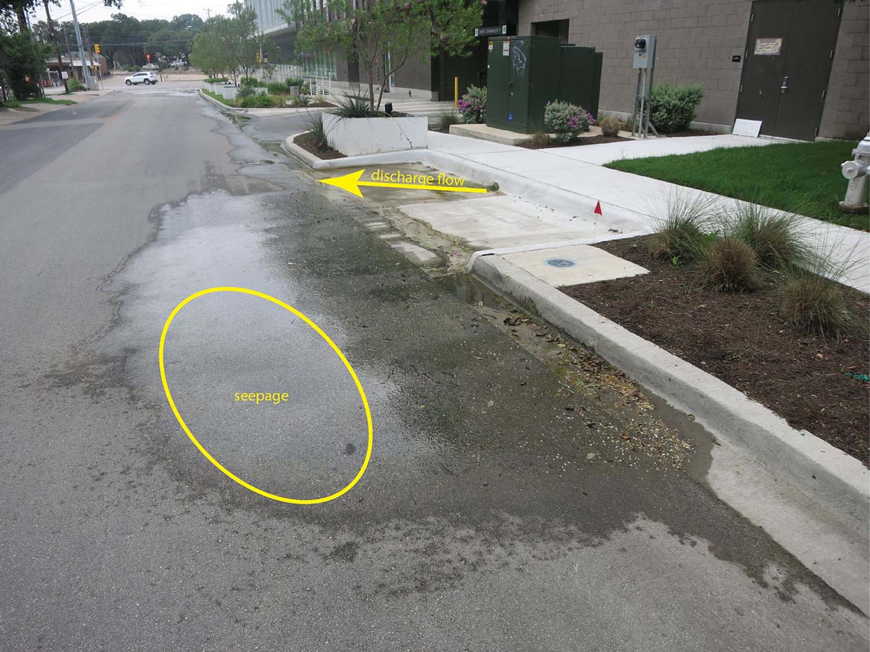
13 Jul 2021 - oval shows area of seepage and arrow shows pipe discharge route (click image to enlarge)
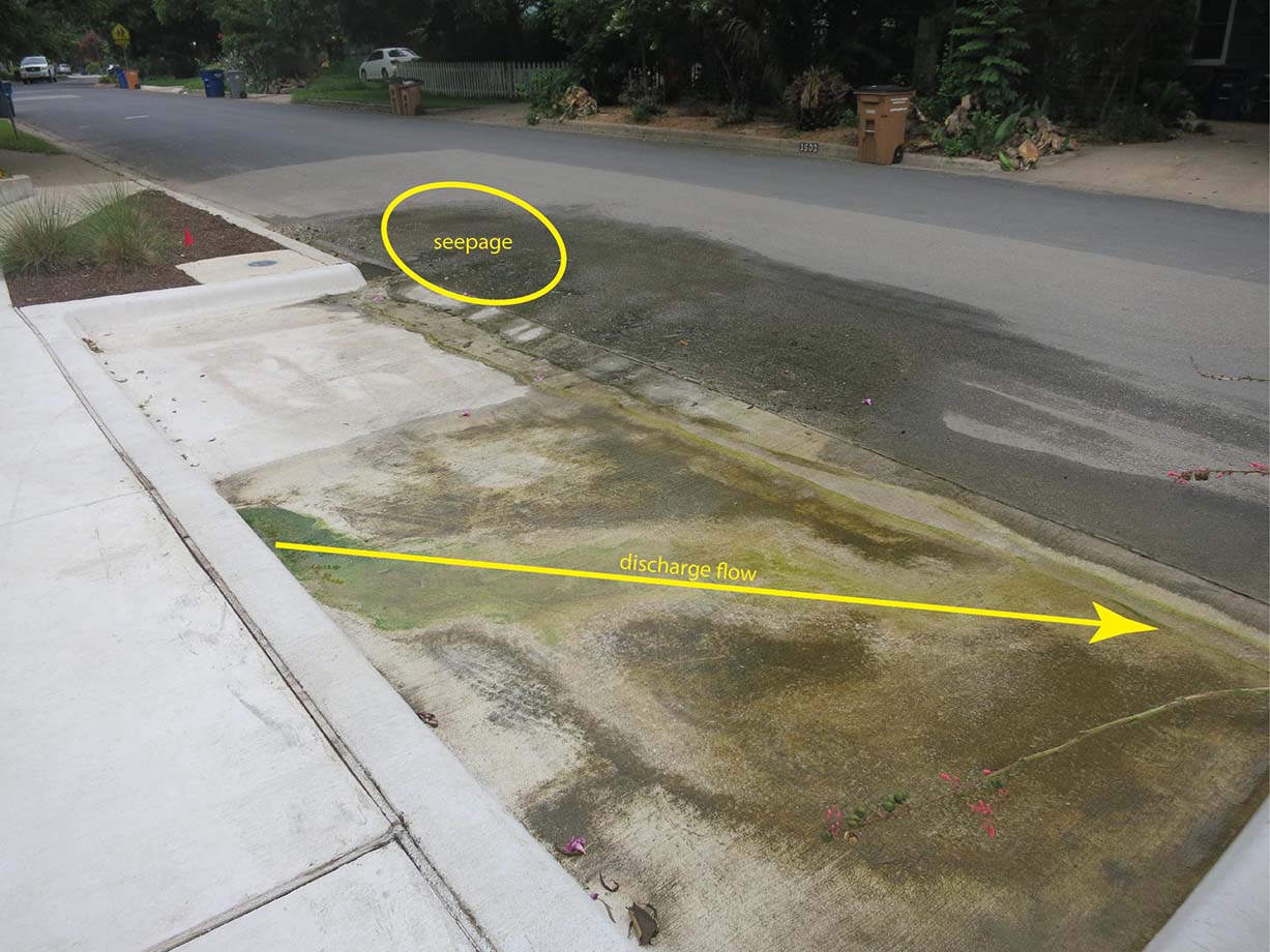
13 Jul 2021 - oval shows area of seepage and arrow shows pipe discharge route (click image to enlarge)
David Boswell, a supervising engineer in the Public Works Department, has provided more information on ZNA's question about maintenance of the street. He indicated that the development has not yet received a Final Acceptance from the City, and therefore, Public Works has asked the Development Services Department to inform the developer of their responsibility to maintain the pavement and correct deficiencies in a timely manner. Public Works does not plan to sign off on any final inspection until an alternative to the groundwater discharge is implemented and the roadway repaired to an acceptable condition. Final Acceptance is when the City, after a final inspection of the project, agrees that the project has been constructed in accordance with the plans and specifications. After the standard one-year warranty period which follows final acceptance, the city would then assume maintenance responsibility for the street pavement.
29 Jun 2021 Update.The pothole from four days ago (25 June 2021) has been patched. It is not clear whether the City patched it or the building owner patched it. No effort was made to clear the road of debris created by the previous pothole. It is a dangerous situation for bikes, both from the scattered debris and how close to traffic bicyclists must ride on South Lamar to avoid the water. Anyone crossing the crosswalk across Hether must walk through water.
.JPG)
29 Jun 2021 - water being discharged and flowing two or three feet out into the street
.JPG)
29 Jun 2021- the most recent pothole has been patched but the debris from it has been left out in the street, and people using the crosswalk will have to walk through the water
.JPG)
29 Jun 2021 - water flowing down the bike lane on Lamar requires bicylists to ride very close to the traffic to avoid the water (looking upstream toward Hether)
This video follows the flow of water from the discharge pipe on Hether to the storm sewer on South Lamar.
25 Jun 2021 Update.
The small pothole that had developed after the street repaving appears to have been patched by June 22, but it didn't last long. The pothole is even larger now with debris spread across the street.
.JPG)
22 Jun 2021 - it appears that the pothole was patched (though still depressed) but . . .
.JPG)
25 Jun 2021- the patch did not last long and the pothole is even bigger now
.jpg)
25 Jun 2021 - closeup
14 Jun 2021 Update.
The street repaving was completed a little over a month ago, and the construction related to the rerouted discharge pipe and sidewalk repairs was completed 2-3 weeks ago, but the warning sign and barriers have not yet to be removed. In this short time, a small pothole has already developed and pavement debris is starting to spread across the street. If water continues to constantly flow down the street and across the intersection, this will be a continuing maintenance problem and safety issue for the next 3-4 years until the proposed stormwater sewers are installed. ZNA is still waiting to receive the results of the groundwater study that was supposed to be provided 5 weeks ago and is also waiting to hear an opinion from the City's legal department that was supposed to be provided 3 weeks ago concerning the compensation issue for the damage done by the owner. ZNA has sent an email to the City once again requesting these responses.
.jpg)
14 Jun 2021 - warning signs still partially blocking street even though construction has been completed
.jpg)
14 Jun 2021- a small pothole has already developed
.jpg)
14 Jun 2021 - pavement debris is starting to spread across the street once again
09 May 2021 Update.
The City Public Works Department completed the repaving of Hether Street near South Lamar Blvd. The following photos and video show how the discharge will continue to be a nuisance, although the potholes are now gone. It appears that water continues to partially enter into the area where the crosswalk is.
.jpg)
09 May 2021 - water extends 3-4 feet into street
.jpg)
09 May 2021- water still intruding into crosswalk
.jpg)
09 May 2021 - water extends well out into the street
.jpg)
09 May 2021 - no erosion controls around area of construction
07 May 2021 Update.
On May 7, 2021, Bill Bunch and Bruce Wiland with ZNA met with City again. Present were Donna Tiemann, Ken Craig, and Dora Anguiano from Councilmember Kitchen's staff and Denise Lucas (DSD), Jose Guerrero (WPD), David Boswell (PWD), Samuel West (PWD), and Erica Lopez (Legal) from the City staff. Public Works (PWD) indicated that the regrading and repaving would start and be completed on Saturday, May 8, 2021. Construction related to Site Plan Correction 6C has commenced and is continuing. Many of the question we asked in the initial meeting and that were supposed to be answered 3 weeks ago have still not been addressed. We had requested information on the groundwater discharge including water quality data, flow volume, and then nature of the groundwater source. WPD is supposed to proved us with the results of a groundwater study next week that is supposed to answer those questions. We are awaiting an answer from the City's legal department on whether the owner can be required to compensate the City for the damage they have done to the street. Donna Tiemann pressed the City staff on whether water reuse options for the landscaping could be investigated. Public Works also mentioned another possible project that they are looking at which consists of constructing a tunnel under South Lamar all the way to the river that would take stormwater drainage from the area rather than directing it to West Bouldin Creek which already has flooding issues.
15 Apr 2021 Update.
On April 15, 2021, a City right-of-way permit for the site plan correction project was issued. The City is now saying that the contractor will start work on Monday, April 26 and that they are postponing their follow-up meeting with ZNA an additional three weeks until May 7.
26 Mar 2021 Update.
On March 26, 2021, ZNA and Councilmember Ann Kitchen met with the Development Services Department (DSD), Watershed Protection Department (WPD), and Public Works about this issue. In this meeting, DSD said the owner's contractor is working with City Right of Way Management to obtain a right-of-way permit for the site plan correction project with construction expected to begin soon and completed by May 1, 2021. Public Works said the City will regrade and repave Hether near the Lamar intersection while the contractor is completing this project. Hether will be closed during the construction. City staff is looking at other options and issues raised by ZNA and Councilmember Kitchen including how this project disrupted the groundwater flow, how to prevent similar occurrences in the future, and whether the builder could be held accountable for the maintenance cost now being bourne by the City and its taxpayers. We were told that the City would report back to us in three weeks (i.e., around April 16).
This current project will only correct the water flowing over the sidewalk. It will not correct the problem of water flowing down the gutter and across Hether near the crosswalk. The City currently has no immediate plans to deal with this problem other than approving the Site Plan Correction and regrading/repaving a portion of Hether, which they hope will prevent water from entering the crosswalk. The underlying issue described in the NOV (not tying directly into the storm sewer) has not been addressed by these plans.
The City has indicated that it is working on a long-term solution of tying the discharge into a future stormwater line. This stormwater line will be installed in the middle of Hether from Kinney to Lamar and then continuing along West Mary to Bouldin Creek. According to the City, planning for this stormwater line is currently underway as part of the South Lamar Corridor Improvements and construction is expected to begin in 2024.
04 Feb 2021 Update.
The following photos and videos show the discharge and the damage it continues to cause (click images to enlarge).
.jpg)
04 Feb 2021 - beginning of periodic discharge
.jpg)
04 Feb 2021- water inundating crosswalk
.jpg)
04 Feb 2021 - large chunk of asphalt
Note the pedestrian having to walk out of the crosswalk and closer to the traffic.
- Additional Photos [04 Feb 2021] (<1 MB PDF)
31 Jul 2020 Update.
The owner put in a pipe and the water now discharges to the concrete drive where it runs across the sidewalk to the gutter and then again flows down the gutter to South Lamar, crosses Hether, and flows down South Lamar to the stormwater sewer inlet on South Lamar. The constant water flow is causing significant damage to the street.
.jpg)
20 Jul 2019
.jpg)
23 Mar 2020
.jpg)
31 Jul 2020
- Additional Photos [31 July 2020] (<1 MB PDF)
This constant flow of water across the sidewalk and driveway has resulted in numerous complaints to the City, and property owner was issued a Notice of Violation on March 12, 2020. It stated that "all plumbing fixtures shall be properly connected to either a public sewer system or to an approved private sewage disposal system" and recommended removing the current system or redirecting the water into a proper sewer drainage system. The nearest stormwater inlet is on South Lamar at Caliber Collision, a little over 350 feet from the corner of the 2010 South Lamar property. This is claimed to be too far away to tie into, and the City of Austin South Lamar CIP will not be installing any new storm drain pipe in this area anytime soon. However, based on the City's stormwater system infrastructure map, there does appear to be an 8" pipe that extends within 150 feet of the property, but the City has not made any indication that this pipe can be used to tie into.
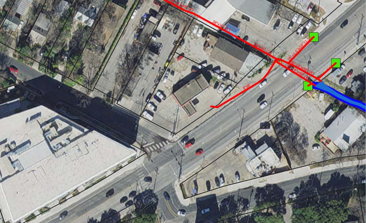
The red lines are the stormwater lines and the green squares are the stormwater inlets.
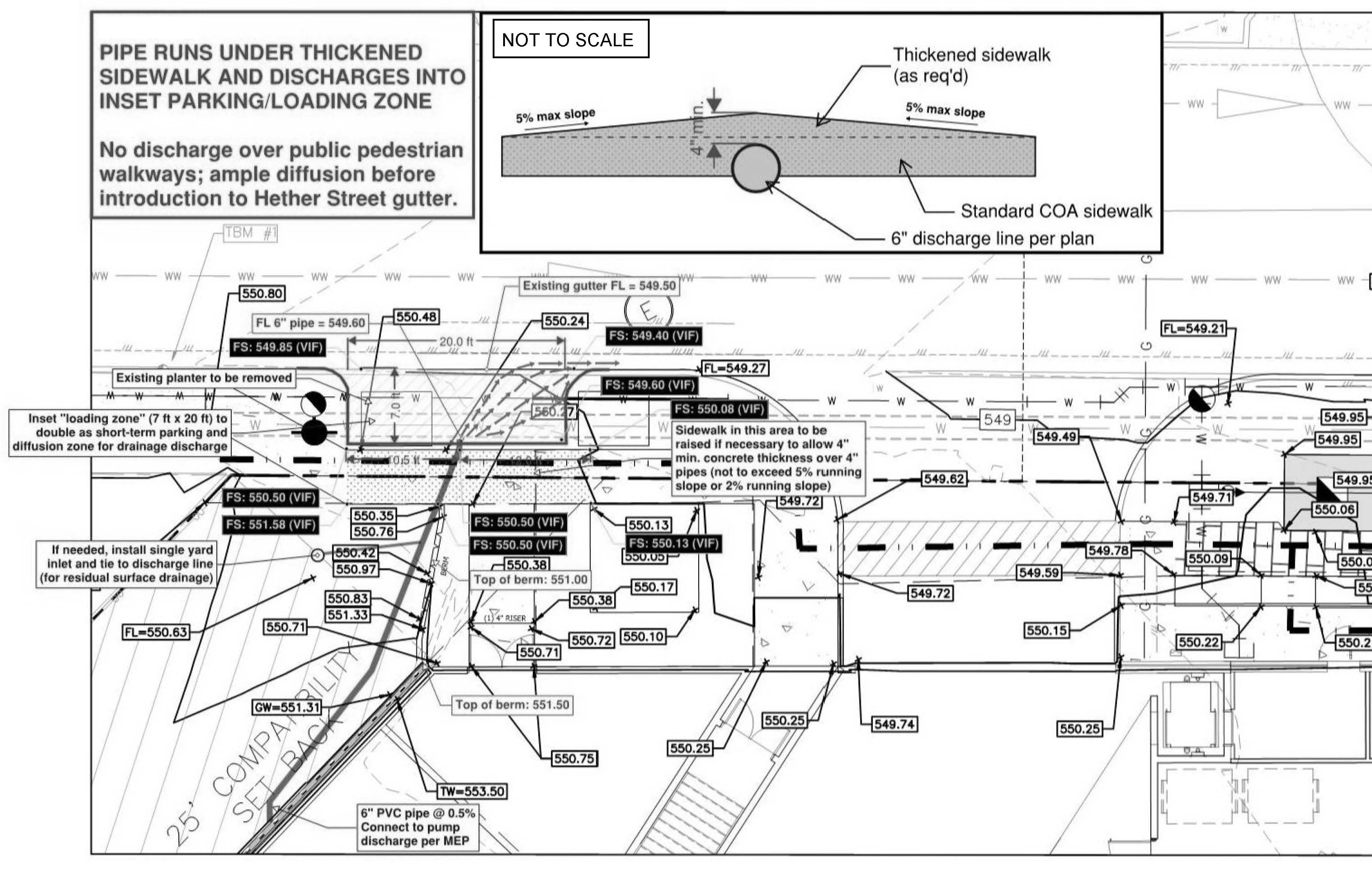
To resolve the NOV, the owners applied for and received approval on June 10, 2020 for a Site Plan Correction to allow the water to flow under the sidewalk and then sheetflow through a pseudo-loading zone to the gutter. This change should stop the flow of water across the sidewalk. However, the water will still flow down the gutter, cross Hether Street at the crosswalk, and flow down South Lamar Blvd to the stormwater inlet.
Here are a few additional documents and links related to the Site Plan Correction:
- City Email String Discussing the Issue and Site Plan Correction 6C [31 Mar 2020] (1.3 MB PDF)
- All Site Plan Sheet Changes for Correction 6C (14.6 MB PDF)
- Right-of-Way Permit for Site Plan Correction (external link to AB+C)
12 Mar 2020 Update.
The constant flow of water across the sidewalk and driveway has resulted in numerous complaints to the City, and the property owner was issued a Notice of Violation (NOV) on March 12, 2020. It states that "all plumbing fixtures shall be properly connected to either a public sewer system or to an approved private sewage disposal system" and recommended removing the current system or redirecting the water into a proper sewer drainage system.
- Notice of Violation [12 Mar 2020] (<1 MB PDF)
Original Problem.
Water collecting in the basement of the building is discharged to the grassy area west of the building and then seeps across the sidewalk to the gutter where it flows down the gutter to South Lamar, crosses Hether near the crosswalk, and then continues north on the west side of South Lamar to a stormwater sewer inlet.
.jpg)
08 Jul 2019
.jpg)
07 May 2019
.jpg)
07 May 2019
City Responses to ZNA Questions.
ZNA posed the following questions to City staff in March 2021. We have only been able to obtain piecemeal responses as of August 4, 2021, and many of the responses do not fully answer or address the questions.
1) Why were steps not taken to prevent the spring/groundwater from becoming a persistent problem when the water was encountered during excavation for the building?
2) Do any regulations exist or can they be developed to prevent this type of issue from occurring at other developments?
3) What are the results of the groundwater study that was supposedly completed by the Watershed Protection department at this site?
4) What is the flow rate, frequency, and volume of flow from the water currently being discharged?
5) Has the discharge been sampled (or will it be sampled when the building becomes occupied) for water quality parameters such as oil and grease resulting from cars in the parking garage?
6) Are there any alternatives to discharging the water in the street, such as storing the water and using it for irrigation on the property or nearby properties?
7) Can the owner be required to repair or pay compensation for the damage that construction of the building has created and for the ongoing maintenance of the street damage resulting from this constant water discharge, or are taxpayers expected to pay for it?
Related Emails
- Email String Between ZNA and City [09 May 2021 - 14 Jul 2021] (<1 MB PDF)
- Email String Between ZNA and City [02 Feb 2021 - 23 Mar 2021] (<1 MB PDF)
- Email from Building Owner [08 Feb 2021] (<1 MB PDF)
- Email String Between the City and Owner's Contractor Discussing the Issue and Site Plan Correction 6C [31 Mar 2020] (1.3 MB PDF)
Related Documents.
Related Regulations
- Specifically Prohibited Pollutants [§15-10-22 (24 & 25)] (<1 MB PDF)
- Final Acceptance, Certificates of Compliance, and Certificates of Occupancy [§25-1-361 through §25-1-363] (<1 MB PDF)
- Local Amendments to the Uniform Plumbing Code [§25-12-153 (322.1)] (<1 MB PDF)
Site Plan
Current Site Plan
The sheets below (in PDF format) were current for Correction 6C as of 06 Jun 2020 and may not necessarily be the lastest sheet. To confirm if there are any newer ones, you will need to look at the Corrections Table in the Cover Sheet (page 1) at the bottom of the City's AB+C webpage. For all sheets except the Cover Sheet, the highest number in parenthesis should be the latest sheet from the latest site plan correction.
| Sheet | Title |
|---|---|
| 1 | Cover Sheet |
| 2 | Plat 1 |
| 3 | General Notes-1 |
| 4 | General Notes-2 |
| 5 | Existing Conditions |
| 6 | Erosion Control Plan |
| 7 | Demoliton Plan |
| 8 | Site Plan (includes parking table) |
| 9 | Grading Plan |
| 10 | Existing Drainage Area Map |
| 11 | Proposed Drainage Area Map |
| 12 | Overall Utility Plan |
| 13 | Utility Plan and Profile |
| 14 | Waterline Plan and Profile |
| 15 | Construction Details 1 |
| 16 | Construction Details 2 |
| 17 | Construction Details 3 |
| 18 | Construction Details 4 |
| 19 | Construction Details 5 |
| 20 | Construction Details 6 |
| 21 | Overall Landscape Plan |
Site Plan Corrections (Reference File Name SP-2016-0196C)
- C6 Case 2020-080024 SC (16 Jun 2020; drainage/sidewalk update) PDF of approved application link to CoA Build+Connect webpage
- C5 Case 2019-209495 SC (25 Oct 2019; drainage pipe) PDF of approved application link to CoA Build+Connect webpage
- C4 Case 2019-141741 SC (10 Jul 2019; change of use) PDF of approved application link to CoA Build+Connect webpage
- C3 Case 2018-201868 SC (17 Jan 2019; addition of office space) PDF of approved application link to CoA Build+Connect webpage
- C2 Case 2018-168218 SC (02 Nov 2018; multiple changes) PDF of approved application link to CoA Build+Connect webpage
- C1 Case 2017-106525 SC (31 Aug 2017; revised construction entrances) PDF of approved application link to CoA Build+Connect webpage
Site Plan Application (Case 2016-046310 SP; Reference File Name SP-2016-0196C)
- City of Austin Build+Connect (AMANDA) Webpage (link)
- Approved Site Plan (with Correction C-1) (22MB PDF)
- Site Plan Permit (PDF)
- Site Plan Approval by Planning Commission on Appeal by Developer (PDF)
- Site Plan Denial by City Staff (PDF)
- Master Comment Report U4 [28 Apr 2017] (<1 MB PDF)
- Master Comment Report U3 [02 Apr 2017] (<1 MB PDF)
- Master Comment Report U2 [19 Jan 2017] (<1 MB PDF)
- Master Comment Report U1 [20 Sep 2016] (<1 MB PDF)
- Master Comment Report U0 [27 Jun 2016] (<1 MB PDF)
- Application Case Info U0 [24 May 2016] (1.2 MB PDF)
Back to Development Projects list Back to Site Plans and CUP list